Rucking has taken off in Australia, and it's easy to see why. Every major city has terrain that's genuinely built for it — coastal boardwalks, bush climbs, riverside paths, and stair sections that turn a straightforward walk into real training. The trick is knowing where to go.
Whether you're after flat distance to build a base or something steep enough to earn it, here's a city-by-city breakdown of the best rucking routes Australia-wide.
Adelaide

Adelaide is one of the best rucking cities in Australia, with serious hill terrain within 30 minutes of the CBD and flat river trails right through the middle of it.
Waterfall Gully to Mount Lofty is the city's signature route and arguably the most ruck-specific trail in South Australia. SA Parks notes it explicitly attracts people training with heavy packs — the 8.8km return covers 450–500m of elevation gain on sealed path and compacted fire track, with excellent forest shade throughout. The summit has a café, toilets, and visitor centre. Arrive early on weekends — the car park fills fast, and the trail closes on days of catastrophic fire danger, so check before you go. One thing worth knowing: the Waterfall Gully car park (230m elevation) is free, but the Crafers Park 'n' Ride with bus connections is a solid alternative.
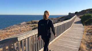
Hallett Cove Boardwalk is a different beast — 7.2km one-way (14.4km return) of coastal trail along dramatic sea cliffs south of Adelaide, with 235m of total climbing packed into constant stair sections and suspension bridges. It's outstanding interval-style leg training under load. One honest note: shade is virtually non-existent. Early morning or late afternoon are the moves in warmer months — golden hour here is genuinely worth the early start. Train stations on the Seaford line sit within 1km of multiple access points if you want to do it one-way.
River Torrens Linear Park Trail is the flat-distance builder. The trail runs 30km end-to-end through the CBD, with paths on both banks — bitumen on one side, gravel on the other — so you can create loops of virtually any distance. Toilets, water, and cafés are spaced throughout. Pick a segment that suits your level: a 6–8km out-and-back from Bonython Park is a solid beginner session.
Belair National Park offers 6.5–15km of customisable bush loops through South Australia's oldest national park. Wide gravel fire tracks are ideal stable footing under load, and the dense eucalyptus canopy keeps temperatures 5–10°C cooler than the plains — a genuine advantage in Adelaide summers. Entry on foot is free; vehicle entry fees apply.
Melbourne

Melbourne's rucking options span everything from a precision training loop in the CBD to a rainforest stair climb in the Dandenong Ranges.
The Tan Track circling the Royal Botanic Gardens is Melbourne's most accessible ruck. Each 3.8km lap runs on compacted gravel and tanbark with one genuine challenge: the 600m Anderson Street climb known as "Heartbreak Hill" delivering roughly 40m of elevation per lap. Stack two to four laps for 7.6–15.3km of consistent, joint-friendly loaded walking. The track is floodlit from 5am to midnight, shade covers about 75% of the loop, and tram connections on St Kilda Road make it easy to access without a car. This is the best starting point for Melbourne beginners.
The 1000 Steps (Kokoda Track Memorial Walk) in the Dandenong Ranges is Melbourne's concentrated vertical training option — a 4.3km circuit ascending 770–800 concrete and timber steps through 260m of elevation gain in temperate rainforest, then descending the wider gravel Lyrebird Track. Under load, this is a serious session. Mountain Ash canopy keeps the trail cool on hot days. Free parking at Ferntree Gully Picnic Ground fills by 10am on weekends, so arrive before 8am. A café operates at the base. Dogs are not permitted.
Bay Trail (Brighton to Port Melbourne) runs roughly 12km one-way along Port Phillip Bay on sealed asphalt and concrete, passing the iconic Brighton Bathing Boxes, Elwood Beach, Luna Park, and St Kilda Pier. Train stations and tram routes at multiple points mean you can do one-way rucks with easy returns. For longer sessions, the wider Bay Trail network exceeds 100km around Port Phillip.
You Yangs Peaks Circuit, about an hour southwest of Melbourne, offers 12.3–12.8km over roughly 718m of cumulative elevation gain across rocky granite singletrack and compacted gravel fire roads. This is a build-to route — uneven terrain, varied gradients, and no trail water mean it demands preparation. Free parking at Turntable car park. Bring everything you need.
Sydney

Sydney's terrain is exceptional for rucking — harbour foreshore, coastal cliffs, and genuine bush track within a short distance of the CBD.
The Bay Run around Iron Cove in the Inner West is Sydney's most beginner-friendly ruck: a 7km paved loop with just 13m of total elevation change, separate pedestrian and cyclist lanes, kilometre markers painted on the path, and seven drinking fountains around the course. Toilets and cafés line the route. King George Park in Rozelle provides the best starting point with parking, toilets, and a flat warm-up area.
Bondi to Coogee Coastal Walk covers 6km one-way (12km return) along clifftop paths with roughly 190m of ascent, multiple stair sections between headlands, and five beaches along the route — each with drinking fountains, public toilets, and food options. Shade is virtually absent, so early starts before 8am are strongly recommended on weekends. This is one of Sydney's most popular walks and can be very crowded — weekday mornings are ideal.
Spit Bridge to Manly is arguably Sydney's best all-round ruck: 10km of genuinely varied terrain through Sydney Harbour National Park including harbour foreshore, maintained bush track, boardwalk, sandy beach sections, and sandstone steps, with 224m of total elevation gain. The mix of surfaces builds diverse functional strength under load. Finish in Manly for cafés and the iconic ferry back to Circular Quay. Some beach sections can be knee-deep at high tide — check tide times before setting out.
Royal National Park Coast Track (Bundeena to Wattamolla) is the serious option: 10km one-way of rugged coastal wilderness with roughly 522m of elevation gain on return. Natural bush track, sandstone rock, and sand demand ankle stability and core engagement under load. There is no drinking water between trailheads — carry 2–3 litres minimum — and mobile reception is absent in some sections. Best in autumn, winter, or spring. This one requires experience and preparation.
Brisbane

Brisbane's subtropical heat makes route selection and timing critical. Early morning is non-negotiable on exposed routes — forested trails are the summer default.
Mt Coot-tha Kokoda Track Loop via the Powerful Owl Trail delivers a 9.8km loop with 428m of elevation gain just 7km from Brisbane's CBD. Steep, sustained climbs on compacted earth and loose rock — genuine hill training under load. Mostly shaded by eucalypt forest and subtropical rainforest canopy. Free parking at JC Slaughter Falls Picnic Area; arrive early on weekends. Toilets and picnic facilities at the trailhead, café at the summit lookout.
Enoggera Reservoir Circuit in D'Aguilar National Park covers 11km with 311m of elevation gain through rolling bushland 20 minutes from the CBD. Wide fire trails provide firm, stable footing for loaded walking. The reservoir is open for swimming most of the year — a genuine post-ruck recovery option. The car park closes at approximately 4:30pm, so plan accordingly. No drinking water on the trail.
Brisbane City River Loop offers up to 18.7km of flat, fully paved riverside path through the CBD — City Botanic Gardens, South Bank Parklands, Howard Smith Wharves, and the New Farm Riverwalk. The core loop is 6.4km; bridge crossings let you customise distance. The optional Kangaroo Point stair climb (107 steps) adds intensity. Facilities are abundant throughout, and many sections are lit for evening rucks. Free parking at New Farm Park on weekdays.
Sandgate–Shorncliffe–Brighton Foreshore Walk provides 6–12km of sealed promenade along Bramble Bay with constant Moreton Bay views and reliable sea breezes that help manage Brisbane's subtropical heat. Wide, flat, purpose-built path. Ample free parking along Flinders Parade, toilets, water fountains, and BBQ facilities spread along the foreshore. Accessible via Sandgate railway station.
Perth

Perth's Indian Ocean coastline, Kings Park, and the Darling Range give the city a rucking range most cities would envy.
Sunset Coast Path (Trigg Beach to Hillarys Boat Harbour) runs 7–8km one-way (14–16km return) along Perth's northern coastline on entirely sealed bitumen and concrete with uninterrupted Indian Ocean views across Marmion Marine Park. The afternoon "Fremantle Doctor" sea breeze provides natural cooling. Free parking at Clarko Reserve and Hillarys Boat Harbour. Toilets, water, showers, and cafés at multiple points. Shade is virtually non-existent — sun protection is critical. For serious distance, the broader Sunset Coast path extends 21.7km one-way from Cottesloe to Hillarys.
Kings Park Perimeter Loop plus Kokoda Track delivers an 8.5–11km urban ruck through one of the world's largest inner-city parks — concreted perimeter paths with bushland dirt trails and a signature stair challenge. The Kokoda Track Memorial Walk features 150 steep steps climbing 62 vertical metres, ideal for weighted stair repeats. The 8.5km perimeter loop gains roughly 161m of total elevation. Sweeping views of the Swan River and Perth CBD. Accessible via the free Blue CAT bus from Perth CBD.
Bold Park Zamia Trail offers a compact 5–8km loop through banksia and tuart woodland with 143m of elevation gain — remarkably hilly for its short distance. Compacted limestone and gravel surface with some sandy sections. Reabold Hill (85m) provides rare dual views of both the Indian Ocean and Perth skyline. Quieter than Kings Park, making it excellent for focused weekday rucks. No drinking water in the park — bring a minimum of 2 litres.
Eagle View Walk Trail in John Forrest National Park is Perth's premier serious rucking trail: a 15–16km loop with approximately 430m of cumulative elevation gain through the Darling Range, about 40 minutes east of the CBD. Rocky singletrack and wide compacted gravel service roads build genuine ankle stability under load. Distance markers every 2km help with pacing. No water on the trail — carry 2–3 litres minimum. Allow 4–6 hours with a loaded pack. National park entry fee applies (~$15/vehicle). Build up to this one.
What to carry
For routes under 8km on well-serviced paths you're covered with a standard water bottle. On anything longer — particularly the trail options in Sydney, Brisbane, and Perth where water points are sparse — a hydration bladder is worth having. Ruckaway's hydration bladder holds 2 litres and sits neatly inside the pack without affecting weight distribution.
The routes above span everything from a beginner's first loaded walk to full-day trail efforts. If you're just getting started, the flat loops — Torrens, The Tan, Bay Run, Brisbane River Loop, Sunset Coast — are the right entry point. Build distance before you add elevation, and add elevation before you go remote.
If you haven't dialled in your gear yet, the Ruckaway rucking backpack is purpose-built for Australian conditions — structured to carry weight high and close to the spine, with a hip belt to shift load on longer efforts, and an airflow channel to manage the heat on exposed routes like Bondi to Coogee and Hallett Cove.
For everything you need to know about getting started — weight selection, form, progression — the complete beginner's guide covers it all.
Now lace up and get out there.